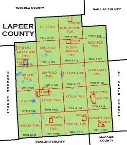
Esther’s probate gave a nice description of the land that was sold after her death. It would be a good idea to study deeds in the courthouse records in Lapeer County to see if there are anymore records regarding the land. Here is a transcription of the land owned by Esther Brown.
…commencing at a point – twenty eight rods south of the north east corner of section seventeen in township nine (9) north range twelve (12) east-running thence west ten (10) rods thence south four (4) rods thence east ten (10) roads thence north along the east line of said section (4) four roads to place of beginning. Containing 1/4 acre lying and being in the township of Burnside, Lapeer Co. Mich.
The township map above came from the CGI General Land Office of Michigan at this link: http://www.michigan.gov/cgi/0,1607,7-158-52927_53037_12540_13083-31058–,00.html This shows that Burnside township is in the northeast corner.
The land described above is located in the northeast corner of Section 17. A rod is equal to 16.5 feet.
This map of the township showing the sections was found at the Michigan County Histories website referencing the Atlas and Plat book of Lapeer County, Michigan, author Kenyon Co., probably done around the first World War. Section 17 is right under the “R” in “BURNSIDE.” The description above place the land place the land in the northeast corner of Section 17.
We could get more specific on the land by drawing a plat of the land as described above and then imposing it on a map of the area. I will put that on my to-do list.


Hi, Just stumbled upon your blog when researching my Great, Great, Grandmother Esther Brown. Very good information I plan to dig through more to follow her lineage back through Canada like so many of my other ancestors.
Here are a few better plat maps for you to use when you get to your to-do list.
http://www.historicmapworks.com/Map/US/21202/Burnside+Township/Lapeer+County+1921/Michigan/
http://www.historicmapworks.com/Atlas/US/12138/
If I understand your property description correctly it appears that Esther’s land was in the “town” of Burnside. A 1/4 acre is too small to be reflected on a plat map so you will not find her name on these unfortunately
Her son (my Great Grandfather George Robson) owned 80 acres at the time of the 1921 plat map as seen in the lower right corner of section 36 so you can see her presence in this regard. I have good memories of my Grandfather’s dairy 160 acre dairy farm there (Jay Gould Robson). I’m not sure when the 2-80 acre parcels were merged to create the 160 but George married Elva Gould from the adjacent parcel so that’s a likely factor.
Randall: This is great information, thanks so much. Esther’s maiden name was King, I am assuming you know that? I have tried figure out her background but it has not been easy. My to do list includes studying Prince Edward County, not the Island. That seems to be an interesting place. I was pretty much all over Hastings Co., Ontario and LaPeer Co., Michigan, visiting them. I will study what you have shared. Canadian research is always a challenge. I do have some information on the Robson’s, as I recall it was a tough research issue.
Thanks for stopping by. We can take this off line. Don’t worry only I can see your info.